
Page 100 - คู่มือการถ่ายทอดองค์ความรู้ของครูภูมิปัญญาท้องถิ่น อำเภอระโนด จังหวัดสงขลา
P. 100
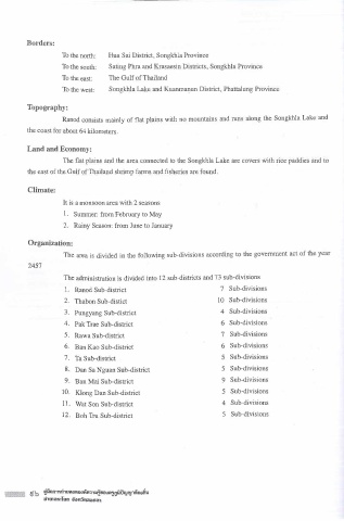
Borders:
                      To the north:   Hua Sai District, Songkhla Province

                      To the south:   Sating Phra and Krasaesin Districts, Songkhla Province
                                               T
                      To the east:   T h e Gulf of  h ailand
                      To the west:   Songkhla Lake and Kuanmanun District, Phattalung Province


          Topography:
                      Ranod consists mainly of flat plains with no mountains and runs along the Songkhla Lake and

          the coast for about 64 kilometers.

          Land and Economy:
                      The flat plains and the area connected to the Songkhla Lake are covers with rice paddies and to

           the east of the Gulf of Thailand shrimp farms and fisheries are found.

           Climate:

                      It is a monsoon area with 2 seasons
                      1  .  Summer: from February to May
                      2. Rainy Season: from June to January


           Organization:
                      T h e area is divided in the following sub-divisions according to the government act of the year
           2457
                      T h e administration is divided into 12 sub-districts and 73 sub-divisions

                      I.  Ranod Sub-district                            7  Sub-divisions
                      2.  Thabon Sub-distict                           10  Sub-divisions

                      3.  Pungyang Sub-district                         4  Sub-divisions
                      4.  Pak Trae Sub-district                         6  Sub-divisions
                      5.  Rawa Sub-district                             7  Sub-divisions
                      6.  Ban Kao Sub-district                          6  Sub-divisions
                      7.  Ta Sub-district                               5  Sub-divisions

                      8.  Dan Sa Nguan Sub-district                     5  Sub-divisions
                      9.  Ban Mai Sub-district                          9  Sub-divisions
                      10. Klong Dan Sub-district                        5  Sub-divisions

                      11. Wat Son Sub-district                          4  Sub-divisions
                      12. Bob Tru Sub-district                          5  Sub-divisions


                                     vv
                �ilon1,ri,uwiot10.ifli..,,11,t10.it1,niiiliy ry1\'10.iii'U
                ihmi>s:luo  ii;,nSoailoa�